


وصف لـ GPS Map Ruler - Distance Measure & Area Measure
GPS Map Ruler is a map measurement app, functioning as a virtual map ruler, which can be used for distance measurement between two points, as well as for distance measurement among multiple points and area measurement. By selecting several different locations on the GPS map, measuring out the distance or area can be quickly achieved.
Features
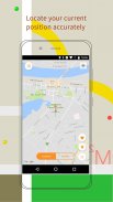
1. Location: locate your current position, also free to select the location
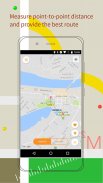
2. Distance measurement: measure the point-to-point distance, choose any route you want by using our distance measure
3. Map selection: multiple maps available, including regular maps and satellite maps
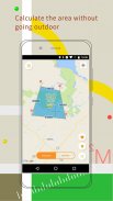
4. Area measurement: measure area on the digital map without going outdoor
Use GPS Map Ruler to make your distance measurement and area measurement easier and faster so as to make your travel, going out and survey more convenient
GPS Map Ruler هو تطبيق لقياس الخريطة ، يعمل كمسؤول خريطة افتراضي ، والذي يمكن استخدامه لقياس المسافة بين نقطتين ، وكذلك لقياس المسافة بين نقاط متعددة وقياس المساحة. عن طريق اختيار عدة مواقع مختلفة على خريطة GPS ، يمكن قياس مدى المسافة أو المنطقة بسرعة.
الميزات
1. الموقع: تحديد موقع موقعك الحالي ، أيضا حر في اختيار الموقع
2. قياس المسافة: قم بقياس المسافة من نقطة إلى نقطة ، اختر أي طريق تريده باستخدام مقياس المسافة لدينا
3. اختيار الخريطة: تتوفر خرائط متعددة ، بما في ذلك الخرائط العادية والخرائط عبر الأقمار الصناعية
4. قياس المنطقة: قياس المساحة على الخريطة الرقمية دون الذهاب في الهواء الطلق
استخدم أداة GPS Map Ruler لإتاحة قياس المسافة والمساحة بشكل أسهل وأسرع وذلك لجعل سفرك والخروج والاستطلاع أكثر ملاءمة
GPS Map Ruler - Distance Measure & Area Measure - إصدار 1.9.3
(31-08-2023)GPS Map Ruler - Distance Measure & Area Measure - معلومات APK
نُسخة APK: 1.9.3الحزمة: com.lixiangdong.mapruleتطبيقات من الفئة نفسها
قد يعجبك أيضًا...


